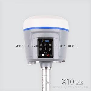
X10 gnss RTK gps
Product Description
|
CHC RTK GPS X10
|
▪ Light & ultra-rugged eliminates user fatigue
▪ Advanced connectivity integrates into any process with nearly any hardware
▪ Common work flows without a data collector
▪ Future proof design for years of productivity
|
GNSS characteristics |
|
|
220 channels |
with simultaneously tracked satellite signals |
|
|
GPS: L1C/A, L1C, L2C, L2E, L5 |
|
|
GLONASS: L1C/A,L1P, L2C/A, L2P, L3 |
|
|
SBAS: L1C/A, L5 (QZSS, WAAS, EGNOS, GAGAN) |
|
|
Galileo: E1, E5A, E5B |
|
|
BeiDou: B1, B2 |
|
GNSS Accuracies(1) |
|
|
SBAS differential positioning accuracy: 0.5 m RMS |
|
|
High-precision static |
Horizontal: 3.0 mm + 0.1 ppm RMS |
|
|
Vertical: 3.5 mm + 0.4 ppm RMS |
|
Post-Processed Kinematic (PPK) |
Horizontal: 8 mm + 1 ppm RMS |
|
|
Vertical: 15 mm + 1 ppm RMS |
|
RTK |
Horizontal: 8 mm + 1 ppm RMS |
|
|
Vertical: 15 mm + 1 ppm RMS |
|
|
Initialization time < 5 s |
|
|
Initialization reliability > 99.9% |
|
Network RTK |
Horizontal: 8 mm + 0.5 ppm RMS |
|
|
Vertical: 15 mm + 0.5 ppm RMS |
|
|
Initialization time < 10 s |
|
|
Initialization reliability > 99.9% |
|
Hardware |
|
|
Dimensions (H×W) |
14 cm × 12.4 cm (5.5 in x 4.9 in) |
|
Weight |
1.22 kg (2.69 lbs) with batteries |
|
Environment |
|
|
Operating |
-40 °C to +75 °C (-40°F to 167°F) |
|
Storage |
-55 °C to +85°C (-67°F to 185°F) |
|
Humidity |
100% condensation |
|
Dust and Waterproof |
IP68, protected from temporary immersion to depth of 1 m (unit floats) |
|
Shock and vibration |
3 m (9.8 ft) pole drop onto concrete, MIL-STD-810G |
|
LCD |
128x64dpi sunlight readable with function/accept buttons |
|
Certification and Calibrations |
|
|
FCC Part 15 (Class B Device), FCC Part 22, 24, 90; CE Mark; C-Tick; Bluetooth EPL, NGS Antenna Calibration, IGS Antenna Calibration, MIL-STD-810G. |
|
|
Communications and Data Recording(2) |
|
|
Serial |
2 x 7pin LEMO port (external power, USB data download, USB update, RS-232) |
|
External Power |
12 to 36 VDC |
|
USB |
v2 - mounts as high-speed USB thumb drive |
|
Cellular |
Internally integrated 3.75G modem (optional 4G modem) |
|
|
HSPA+ 21 Mbps (download), 5.76 Mbps (upload) |
|
|
WCDMA 850/900/1700/1900/2100 |
|
|
EDGE/GPRS/GSM 850/900/1800/1900 |
|
Bluetooth® |
Internally integrated multimode system compatible with Android, Windows Mobile, iOS and Windows desktop operating systems |
|
WiFi |
802.11 b/g/n, access point mode |
|
UHF Radios (2) |
Protected TNC Female |
|
Standard |
Internal Rx/Tx: 450 - 470 Mhz; transmit power: 0.1 W to 2 W, protocol CHC; range: 5 km optimal conditions |
|
Option 2 |
FCC Certified Internal Rx/Tx: 403- 473 MHz; transmit power: 0.1 W to 1 W, protocols Trimble, Satel, Pacific Crest; range: 5 km optimal conditions |
|
Protocols |
CMR: CMR+, sCMRx input and output |
|
|
RTCM: 2.1, 2.2, 2.3, 3.0, 3.1, 3.2 input and output |
|
|
NMEA 0183 output |
|
|
HCN and RINEX static formats |
|
|
NTRIP |
|
Data Storage |
32 GB high-speed memory |
|
Electrical |
|
|
Power consumption |
<3.2 W |
|
Li-ion battery capacity |
3400 mAh*2, 7.4 V |
|
Operating time |
Setup of multiple data stream |
|
External power |
12 to 36 V DC |
Product Image

